Alpine Hiking in Whistler
Fall is creeping in, but there’s still time for Alpine Hiking in Whistler! The Whistler Village Gondola will transition to limited hours starting in September, but there are still ways to access the alpine if you have the gear and fitness. Exploring Whistler’s trail network is truly a magical experience, but it’s not one to take lightly in regards to safety. Before embarking on any of the below alpine hikes, we highly recommend taking a look at this safety checklist for hikers. Okay, ready to explore? Let’s go!
Rainbow Lake Trail
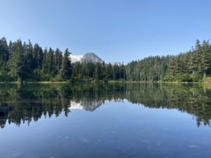
Located on the West Side of Whistler (opposite Blackcomb Mountain), Rainbow Lake Trail will give you a new perspective of the valley. Before we explain why this trail should be on your list, make sure you always check this website for Wildlife Updates, as there is a resident Grizzly Bear on Rainbow Mountain! Now, for the trail… the trail to Rainbow Lake leads you through stunning forests and past Rainbow Falls, accompanied by a challenging elevation gain. It’s worth it though! Once you break through the trees and into the alpine, you’ll be greeted with the epic vistas of Rainbow Lake. Rainbow Lake is at the base of Rainbow Mountain, and you’ll be in awe of the magnitude of this mountain. Just to note: swimming isn’t allowed in Rainbow Lake, as it’s part of the Whistler watershed that supplies our drinking water!

-
-
- Difficulty: Intermediate
- Distance: 16km round trip
- Elevation Gain: 850m
- Time Needed: 6-7 hours
- How to Get There: From Whistler Village, head south on Highway 99, then turn right on Alta Lake Road. Follow it for 6km to the trailhead and the parking area is on the left side of the road.
-
Skywalk Trails
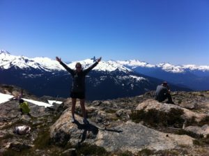
Another West Side classic is the magnificent Skywalk Trails: Skywalk South, 19 Mile Creek, and Skywalk North. These trails are part of Whistler’s newest alpine network located on the northeast face of Rainbow Mountain. All three of these trails emerge into the alpine near the glacial water of Iceberg Lake. You’ll definitely want to hang out and take some pictures of the lake and its surrounding mountains!
-
-
- Difficulty: Difficult
- Distance: Up to 20km
- Elevation Gain: 1025m
- Time Needed: 9 hours
- How to Get There: The Skywalk North and 19 Mile Creek trails start at the end of Mountain View Drive in the Alpine Meadows neighbourhood. Drive Highway 99 north and turn left on Meadow Lane into Alpine Meadows. Immediately turn right onto Parkwood Drive, then go left on Mountain View Drive and follow it to the end. Optionally, take bus route 30 and get off at the intersection of Mountain View Drive and Valley Drive.
- Difficulty: Difficult
-
Blackcomb Ascent Trail
If you’d prefer to stay on the Whistler and Blackcomb side of the Valley, The Blackcomb Ascent Trail is a challenging and direct trek up Blackcomb Mountain. It’s sectioned off into what’s collectively called the Burns: Little Burn & Big Burn. Little Burn allows you to duck out at the gondola’s mid-station, while Big Burn takes you to the top. If you’re hoping for a lift down the mountain, make sure to check the gondola schedule before you go! If you make it to the top, you’ll have access to the network of alpine trails on Blackcomb mountain, and you can find a map here.
-
-
- Difficulty: Difficult
- Distance: 6.1km one-way
- Elevation Gain: 1175m
- Time Needed: 3.5 hours
- How to Get There: The trail starts at Blackcomb Base on Blackcomb Way in Whistler.
-
Singing Pass to Russet Lake
Singing Pass Trail is a long hiking trail that offers free access into the gorgeous alpine between Whistler and Blackcomb Peaks in Garibaldi Provincial Park. This is a great option for those who don’t want to be tied to the schedule of the gondola but still want to venture into Whistler’s backcountry. The trail itself isn’t the most scenic, but it ends at Russet Lake, surrounded by glaciated peaks and stunning vistas. You can also use this trail to connect with the Musical Bumps or High Note Trails to Whistler Peak.
-
-
- Difficulty: Experienced hikers only
- Distance: 31km round trip
- Elevation Gain: 1280m
- Time Needed: 10-11 hours
- How to Get There: The trailhead is next to the Whistler Gondola bus loop on Blackcomb Way.
- Difficulty: Experienced hikers only
-
For help with planning your hiking vacation, check out Deals + Packages or call (604)962-0220 and get local help from the amateur athletes who live and hike in Whistler!
